
PUBLICATIONS
Spatial Foresight team members are actively publishing their research results to make them available to a wider public and also support the Territorial Thinkers.
Below a selection of some of our publications:
- Territorial Thinkers' Briefings
- Spatial Foresight illustrations
Spatial Foresight Briefs
Spatial Foresight Briefs, present key findings from some of our project to a wider public. These very short and focused papers on current themes are easy to access by policy makers and researchers alike.
This Spatial Foresight Brief explores three scenario snapshots which may serve as eye openers to imagining possibilities for the European Union (EU) post COVID-19. Governments across the world have already introduced policies to tackle impacts of the COVID-19 pandemic and the EU has started to implement an ambitious recovery plan. With lockdowns being reimposed, assumptions about a ‘new normal’ are back. The next step is to think and plan for the future. Financial support is seen as key to making the world go round again. Drawing on discussions about options for recovery strategies, this brief gives three scenario snapshots of what could shape post COVID-19 normals in the EU and which territories may be affected more, or less.
Spatial Foresight Brief 2020:14 Scenario snapshots of a post-COVID-19 EU: Recovery strategies shaping new normals
This Spatial Foresight working paper displays considerable and territorially diverse implications of COVID-19 policy responses. These may not be overlooked when assessing the impacts of COVID-19 and discussing measures to mitigate impacts and support recovery. The paper provides a quick rationale on why it is important to understand the territorial implications of COVID-19, or rather the policy responses to the pandemic, and why it is important to understand it in a comparative European perspective. Thereafter, the paper briefly outlines the methodological approach on how to get grip on it. This is followed by the presentation of first draft results. Finally, the paper sketches possible next steps to be taken to further develop, nuance and polish the work. Overall the paper shows the territorially diverse implications of COVID-19 policy responses which may inform discussions about ways forward making best use of the territorial diversity of Europe.
Spatial Foresight Brief 2020:13 Understanding the territorially diverse implications of COVID-19 policy responses
This Spatial Foresight brief opens up a new path to overcome the ‘no-funding’ deadlock that puts the EU macro-regional strategies in anguish. Drawing upon their evolution and glimpsing into their future, the brief argues that macro-regional strategies have come to an age where they have the capacity and experience to design their path independently of Interreg funding. The brief combines the experience on macro-regional strategies with the concept of the Integrated Territorial Investments tool and presents a bold and innovative idea on Macro-regional Integrated Territorial Investments, which could give an answer to how macro-regional strategies can break out of Interreg money.
Spatial Foresight Brief 2019:12 Macro-regional Integrated Territorial Investments: How to break out of Interreg
This Spatial Foresight Brief contributes to the debate on the transition to a circular economy in Europe. The brief illustrates the benefits of developing local and regional circular economy strategies in a coordinated way to further a transition to an economic model that brings consumption and production cycles together to create a resource efficient system that reduces waste to a minimum. EU-level initiatives, programmes and regulations can support the development of these local and regional strategies, in particular by providing a framework to coordinate the transition and to ensure that no territories are left behind.
This brief derives from expertise gathered during different Spatial Foresight projects for example for the European Economic and Social Committee, ESPON, German Federlan Environmental Agency and Luxembourg ministry for sustainable development.
Spatial Foresight Brief 2019: 11 Local and regional strategies accelerating the transition to a balanced circular economy
This Spatial Foresight Brief contributes to the debate around the programming of European Territorial Cooperation 2021-2027, by focusing on possible ways to measure impact and to enhance evaluability. The brief presents the challenge of demonstrating value of transnational Interreg programmes. It sheds light on different approaches to measure and evaluate the impact of Interreg, drawing upon two examples of mid-term evaluations carried out by Spatial Foresight to show how challenging this exercise is and how it can be improved in the future.
Spatial Foresight Brief 2019: 10 Evaluating Interreg Programmes. The challenge of demonstrating results and value of European Territorial Cooperation
At European level, the revision of the Territorial Agenda is currently discussed stressing the need for a stronger territorial dimension in policy making and the empowerment of local and regional players to engage in cooperation and visioning processes. At the same time, in the Western Balkans, there is a bottom-up discussion about the need to strengthen territorial governance and empower civil society players at local and regional level, to improve the quality of public decision making and prepare for European integration. This Spatial Foresight Brief brings these two parallel debates together and highlights that including the Western Balkans in the Territorial Agenda post-2020 is an opportunity not to be missed.
Spatial Foresight & Co-PLAN Institute for Habitat Development Brief 2019:9 The Western Balkans in the Territorial Agenda post-2020: An opportunity not to be missed
Spatial Foresight published a policy paper as a response to the EC White Paper on the future of EU 27 by 2025. In a time of an evolving world, the European Union finds itself in the middle of several crises and needs to take a decision on what future to choose. The EC White Paper presents five possible scenarios for the future of EU27 and aims to initiate a debate and discussion about which path to take. It however ignores the territorial effects that these scenarios have on European regions and cities. The Spatial Foresight position paper gives a response to that and points at some possible territorial implications for each of the five scenarios of the White Paper. The aim is to raise awareness and launch another debate, this time highlighting that territory still matters when aiming at designing desirable futures for the EU and its citizens. You download and read the paper here.
Spatial Foresight Brief 2017:7 The future of Europe. And its territories? A response to the EC White Paper on the future of Europe
This Spatial Foresight Brief first seeks to explain the characteristics and added value of macro regional strategies in the European Union. Second, it explores the specific challenges that arise from this kind of new and more complex types of multi-level governance, linking theoretical insights to practical requirements. Based on these assumptions, a new tool to map and monitor governance systems is presented: the Governance Assessment Scorecard (GOA). This tool offers the opportunity to study in a more detailed and comparable manner different multi-level governance arrangements, thus drawing conclusions for future support to macro regional governance structures.
Spatial Foresight Brief 2016:6 The GOA tool: Assessment of macro regional governance systems
This Spatial Foresight Brief derives from the results of the study “Potentials for transnational and cross-border partnerships by using the EGTC instrument” (original title: "Potenziale für transnationale und grenzüberschreitende Partnerschaften durch Nutzung des Instruments der EVTZ") carried out for the Federal Institute for Research on Building, Urban Affairs and Spatial Development (BBSR) and the Federal Ministry for Transport and Digital Infrastructure, former Federal Ministry for Transport, Building and Urban Development (BMVI) of Germany. It was additionally inspired by discussions about further development of the EGTC instrument at the annual conference of the Academy for Spatial Research and Planning (ARL) in Karlsruhe in 2014.
Spatial Foresight Brief 2014:5 Potential & limits of the EGTC instrument for enhancing integration across borders
This Spatial Foresight Brief derives from internal discussions among Spatial Foresight team members and insights from a range of assignments related to the Europe 2020 Strategy. This includes e.g. studies for the European Commission Directorate General Regional and Urban Policy, ESPON, the German Federal Institute for Research on Building, Urban Affairs and Spatial Development (BBSR) and the German Academy for Spatial Research and Planning (ARL).
Throughout these various studies and discussions the lack of a thorough and constructive territorial dimension of the Europe 2020 Strategy has been highlighted as a major concern.
Spatial Foresight Brief 2014:4 EUROPE 2020 STRATEGY - Contribution to European Public Consultation Process
This Spatial Foresight Brief derives from a background paper commissioned by the European Commission - Directorate General for Regional and Urban Policy in spring 2013. It served as input for the preparation of the report concerning the added value of macro regional strategies (COM(2013) 468 final). The paper is also available as part of the Commission Staff Working Document accompanying the document concerning the added value of macro regional strategies (SWD(2013) 233 final).
Spatial Foresight Brief 2013:3 Added value of Macro regional strategies: A governance perspective
This Spatial Foresight Brief derives from a background paper based on on-going research within the framework of the research project of the German Federal Institute for Research on Building, Urban Affairs and Spatial Development (BBSR) "The territorial dimension of the future EU cohesion policy", conducted by Spatial Foresight GmbH in cooperation with Taurus Eco Consulting GmbH.
Spatial Foresight Brief 2011:2 Possibilities for an Institutional Anchorage of Territorial Cohesion
This Spatial Foresight Brief is based on many years of experience and work in projects addressing the issue of territorial cohesion. The most recent of these are the ESPON INTERCO project on indicators on territorial cohesion, a study of the territorial dimension of the future EU Cohesion Policy carried out for the German Federal Institute for Research on Building, Urban Affairs and Spatial Development (BBSR), and work on how to strengthen the territorial dimension of Europe 2020 and EU Cohesion Policy conducted for the Polish EU Presidency.
Spatial Foresight Brief 2011:1 Territorial Cohesion Storylines: Understanding a Policy Concept
Territorial Thinkers Briefs
Territorial Briefings are short papers by the territorial thinkers with reflections to stimulate further debate. Territorial Thinkers is an independent platform of experts, highly experienced in European, national, regional and local policy development with a territorial dimension. The Briefings address in greater depth the territorial dimension of an important issue to support on-going policy development processes.
Spatial Foresight Illustrations
Spatial Foresight staff members produce different forms of illustrations. These illustrations are the graphic representation of various projects made available to a wider public.
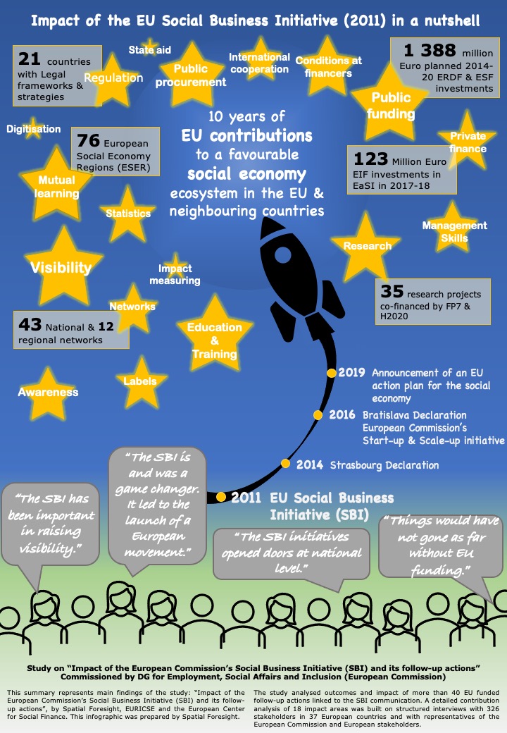
In 2011, the European Commission presented the Social Business Initiative (SBI) which established an EU level action plan with concrete measures to establish a favourable environment for social enterprises. Spatial Foresight led a study assessing the impact of the SBI for the European Commission DG Employment, Social Affairs & Inclusion. The study was conducted in cooperation with EURICSE and ECSF.
The infographic describes the study's findings in a nutshell. The full report is available for download here.
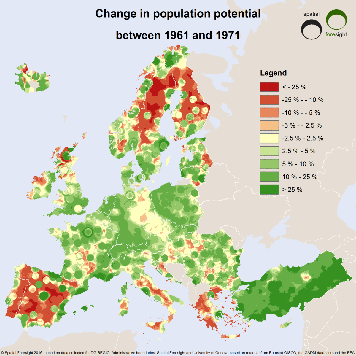
Demographic changes have a major impact on the effectiveness of regional development policies. Whether a region in Europe is shrinking or growing determines its policy need. Also the pace of demographic change is decisive. This is why they are of high interest for European, national and regional policy makers.
Population potential is the total number of persons living within a certain distance of a given place. In utilising population data collected from censuses and registers for the European Commission, Spatial Foresight based the given place on around 7 million 1km2 grid cells. The maps show changes in the number of people living within 50km of each cell for 10 year periods between 1961 and 2011. For the calculation 50 km as a proxy for a daily commuting distance was used.
Illustrating demographic structures with population potentials provides unique advantages compared to more common maps showing trends at the level of municipalities. In common maps, the size of municipalities heavily influences the visual presentation of developments. They give the impression that e.g. there is more intense demographic polarisation in Northern France than in Belgium. This is because French municipalities are much smaller than Belgian ones. Population potentials neutralise these differences. They make it possible to focus on demographic trends, rather than observing the combined effect of municipal delineation logics and population change.
Presenting demographic developments within a daily commuting distance do overcome this risk of misinterpretation and are more relevant from a regional policy perspective. A local redistribution of population between two neighbouring municipalities often just reflects new residential preferences. However, a significant change in the total population within commuting range implies that their economic and social situation has evolved more profoundly.
Even though measuring demographic developments with population potentials provides many advantages, they’re not without drawbacks. The current map uses 50 km Euclidean distance as a proxy for daily commuting distance. It does not take into account the variables quality of transport infrastructure, congestion and obstacles such as mountain ranges, stretches of water or political borders. A better solution would have been to calculate a travel time distance from each point. However, when analysing historical data, one would then have to consider the available road or rail network for each year.
The gif animation of decennial changes in population potentials synthesises a large number of trends at different scales across Europe. Between 1961 and 1971, one is first struck by the intensity of population growth across a large part of Europe. However, there are some significant exceptions, mainly located at the outskirts of the continent, e.g. the Iberian Peninsula, northern Sweden and Finland outside the largest cities, Greece, the Italian Mezzogiorno, northern Scotland and western Ireland.
In the following decade, rates of growth and decline tend to be more moderate. The only exception is Spain and Portugal, where urban-rural polarisation continues with almost unchanged intensity. In Scotland, northern parts actually grow, while there is demographic decline in the Glasgow region and stagnation around Edinburgh. In large parts of Europe, including its core parts, cities and their rural hinterland tend to experience more contrasted demographic developments.
After 1981, demographic growth and decline accelerate but tend to follow the same geographic pattern as previously, e.g. in the Nordic countries, in Eastern Germany and in south-eastern Europe. This acceleration continues after 1991. However, one then in addition observes nation-wide population decline in the Baltic countries, Bulgaria, Romania and Croatia. These trends are accentuated after 2001 in the Baltic countries (except Tallinn) and in Bulgaria. At the same time, a process of intense urban-rural polarisation starts in Turkey, while demographic growth now occurs across the entire territory in large parts of Spain, western and southern France. The demographic dynamism of Ireland between 2001 and 2011 is also striking.
Over the entire period, the population potential decreases steadily in some remote and rural areas, e.g. along the axis running from Lorraine to Auvergne in France or in remote parts of northern Scandinavia. It seems that efforts to mitigate depopulation in these areas can, at best, postpone trends that may appear as inevitable and alleviate their social implications. A better awareness of these trends may help to design policies to manage demographic decline or, when possible, to stabilise population at current levels.
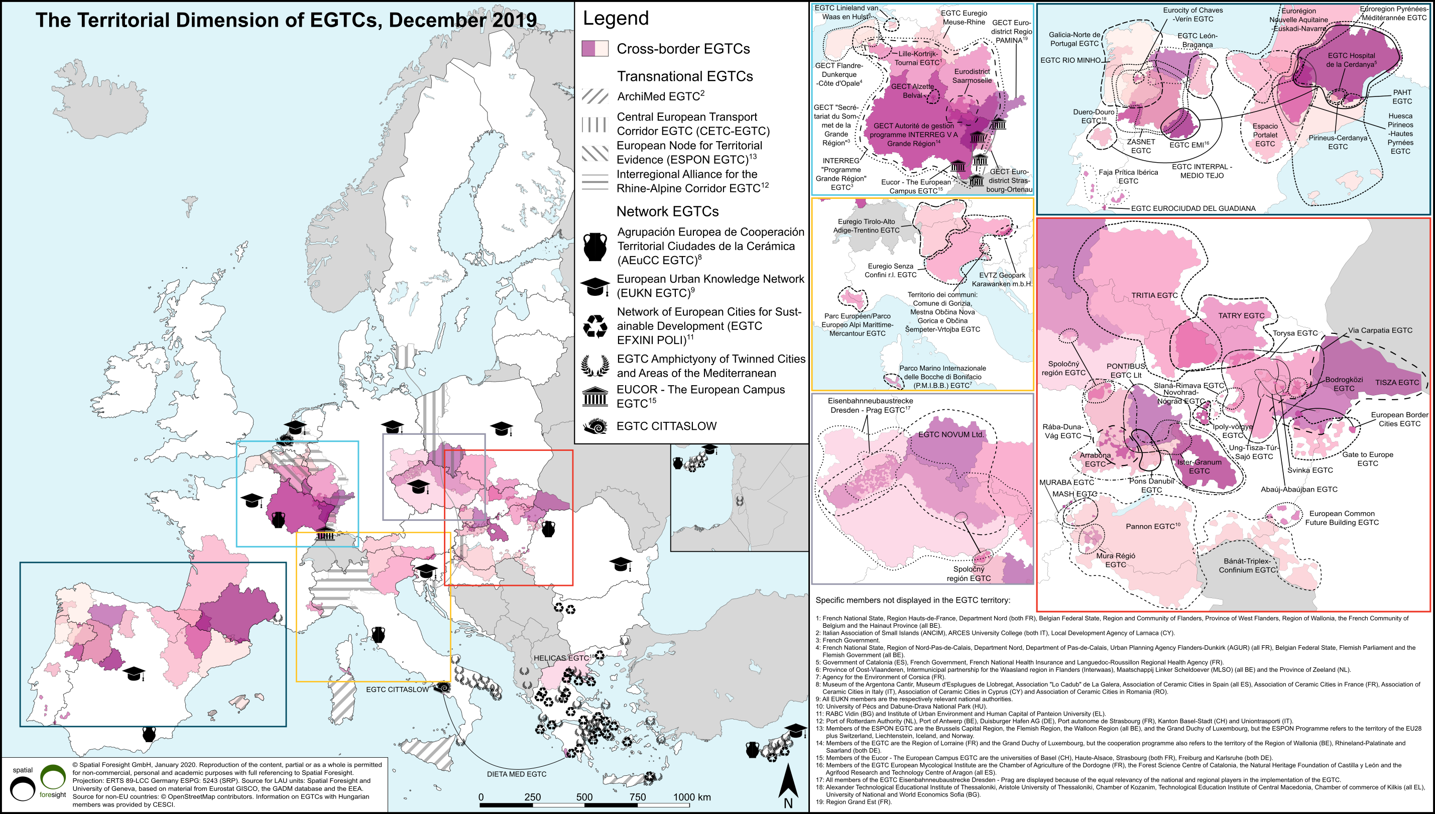
The EGTC (European Grouping of Territorial Cooperation) is a legal EU cohesion policy instrum ent for territorial cooperation introduced in 2006 by adopting Regulation (EC) No 1082/2006. Until December 2017, 69 EGTCs have been established whereas one grouping was dissolved during 2017. Currently there are 68 EGTCs. They may be founded for various purposes and can thus be flexibly applied in different contexts as regards member constellations, thematic foci, or different legal backgrounds in the respective EU Member States and under inclusion of neighbouring countries.
The map illustrates the territorial dimension of the EGTCs founded until December 2017. For depicting EGTCs with respect to their territorial diversity it is useful to differentiate three types. violet depicted are cross-border EGTCs. This is the most frequent type. These EGTCs are most often founded by sub-regional public authorities. Their territorial extents vary however significantly. Transnational EGTCs (hatched) represent the second type. They do not require direct territorial proximity and usually have members from at least three countries. The third type represents so-called network EGTCs (depicted by symbols). Depending on their thematic focus, types of members and objectives, the members can be found in rather distant areas of the EU.
Information and publications based upon Spatial Foresight’s activities related to the EGTC instrument are available online:
BBSR study on disseminating and deepening the experience of EGTC (in German)
Guidelines for the establishment of an EGTC (in German, English and Polish)
Spatial Foresight Brief on potential and limits of the EGTC instrument (in English)
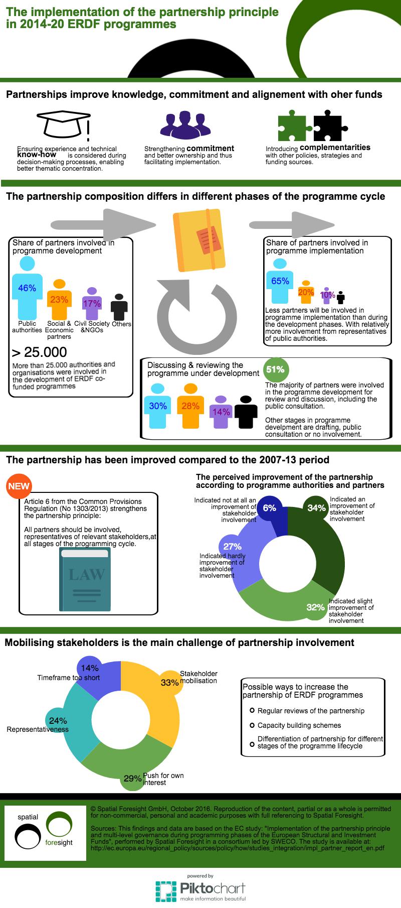
How does partnership in 2014-20 ERDF programmes function?
The partnership principle has been strengthened in ERDF and other ESIF programmes with the adoption of the 2014-2020 regulatory framework. Article 5 of the Common Provision Regulation (CPR) makes it compulsory for each ESIF programme to organise a partnership at all programing stages. A European Code of Conduct has been set up to support EU Member States to ensure the inclusion of different types of stakeholders. Even though the partnership is not completely new for ERDF programmes, more importance has been given to stakeholder involvement and influence.
The infographic illustrates the findings of the DG Regio report on this topic - "Implementation of the partnership principle and multi-level governance in 2014-2020 ESI Funds".
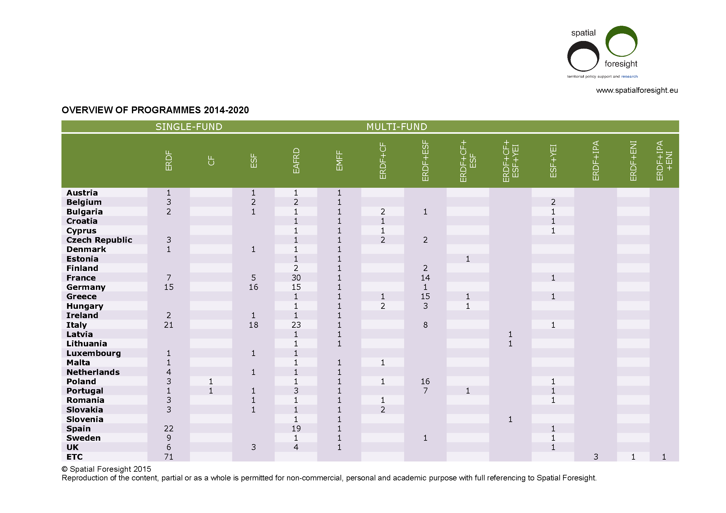
Policy coordination has been a concern for European policy-making. With the introduction of the place-based approach this has gradually found it’s way into EU regulation. The Common Provisions Regulation (CPR) introduced for the 2014 European Structural and Investment Funds (ESI Funds) already supports better coherence and coordination among different ESI Funds. The regulation itself includes more mechanisms for better coordination between funds. One of these mechanisms is the possibility of multi-fund programmes in the 2014-2020 period. Multi-fund programmes combine different ESI-funds. The common regulatory framework has a clear step in improving the coordination and governance across funds. This framework encouraged the use of multi-fund programming.
The table above has been based on the adopted programmes available at the Commission’s webpages and the adopted Partnership Agreements by July 2015. This includes all Partnership Agreements and a fair share of the programmes under the Investment Growth and Jobs and European Territorial Cooperation Goals. In total we expect 490 programmes of which 76 ETC programmes. 110 programmes will be multi-fund programmes, of which 5 are ETC programmes, combining ERDF and funding for EU-neighbouring countries (ENI and/or IPA).
The uptake of the possibility of integrated programmes differs by Member State. Multi-fund programmes are the dominant programme type in France, Greece, Poland and Portugal. Most other Member States won’t make use of the possibility to combine different ESI funds and will have single fund programmes.
Most of the multi-fund programmes will be a combination of the ERDF and ESF, followed by combining the ESF with the Youth Employment Initiative (YEI).
2017: Spatial Foresight's 10th anniversary
In July 2017 Spatial Foresight celebrated its 10th anniversary. 10 years full of hard work and fruitful collaboration with partners and clients. 10 years, during which we have learned from each other and contributed together to the progress and evolution of Cohesion Policy and territorial development all across Europe.
To celebrate this, Spatial Foresight looked back with a storybook illustrated by 10 drawings and organised an innovative and interactive workshop 'Europe re-discovered'.

Spatial Foresight Illustrations
Spatial Foresight staff members produce different forms of illustrations. These illustrations are the graphic representation of various projects made available to a wider public.